Public Safety Projects

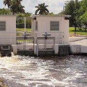
Hurricanes, tropical depressions, and tornados are some of the severe weather events the Lake Worth Drainage District (LWDD) must be prepared to deal with at any given moment. Managing over 500 miles of drainage canals and 1,000 miles of associated rights-of-way is a monumental task. It requires experienced staff working daily to maintain the free flow of water in the channel and unencumbered access along the canal banks.

Often mistakenly perceiving the LWDD rights-of-way as part of their backyard, property owners may enhance the rights-of-way with items like trees, fences, sheds or patio decks. These enhancements, or encroachments, can jeopardize public safety during severe weather. Trees and shrubs can fall into the canal, slowing the progression of drainage or cause blockages at major flood control structures. Additionally, structures placed on the right-of-way, like fences or sheds, can obscure sightlines for visual inspections and impede access for maintenance and emergency response.

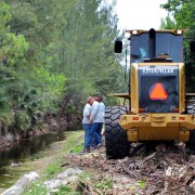
To combat this problem, LWDD has undertaken a Canal Rehabilitation Program. The rehabilitation process includes the removal of encroachments and, if needed, reconstruction of canal banks. Canal rehabilitation is different than regular maintenance operations. Regular canal maintenance is performed on a scheduled basis and includes mowing, aquatic vegetation management, and encroachment removal. Canal rehabilitation is a more intensive operation and occurs on a more infrequent basis. After rehabilitation takes place, the canals are added to the regular maintenance schedule.

In many instances, areas may not have been addressed for several years due to operational priorities. Following Hurricanes Frances and Jeanne in 2004 and Wilma in 2005, the focus switched to providing unencumbered emergency access along both sides of LWDD canals. The goal of rehabilitation is to return the canal and the right-of-way as close as possible to its original design, thus providing optimal flood control operations.

The health, safety, and welfare of our constituents are paramount, and a well-maintained canal system is the best defense against possible flooding. The District estimates the vegetative removal phase of the project will be completed in 2022.

Smart Cover System Case Study

Weekend Weather Update

Technology Enhances Flood Control

South Florida’s tropical weather events can be intense and seriously threaten property and life. In response, the Lake Worth Drainage District (LWDD) monitors canal elevations and makes necessary operational adjustments to its water control structures to provide flood control for the 200 square miles of land within its boundary.

Water control structures act like dams, allowing stormwater to be released or held back depending on weather conditions. The technology used to operate LWDD’s water control structures is called Supervisory Control and Data Acquisition (SCADA). As the water rises in the canal and reaches a pre-determined elevation, SCADA will slowly open control structures releasing water for flood control. Similarly, as water elevations return to normal levels the control structure gates will close, holding back water for conservation and water supply demands.

This response to changes in the canal system happens automatically and can be monitored remotely by staff using mobile devices. However, in anticipation of severe weather, staff can override the automated SCADA system and make manual adjustments as needed. The remote monitoring and operating functions of SCADA eliminates the need for LWDD staff to venture out during dangerous weather conditions to operate control structures, as well as significantly reduces response time.

Another advantage to SCADA is the capture of operational data by the system which can be used to evaluate future water supply needs and historical flood control responses. This data can be shared with regional water management partners for enhanced flood control coordination and water conservation measures.

LWDD is proud to provide the residents and businesses within our boundary this advanced flood control technology.

The Probability of Flood Risk

In some places, homes and businesses constructed in areas known as the 1-in-100-year flood plain have been hit by multiple floods in the same year. The assumption that if their area has experienced a 1-in-100-year flood, then for the next 99 years they do not have to worry about flooding is not correct.  While it’s unlikely that two large storms will happen in close succession, history has demonstrated that it is not impossible.

Confused by the term 1-in-100-year flood, many people begin to wonder what their flood risk really is. The definition of a 1-in-100-year flood is a flood that has a 1% chance of occurring in any given year. Understanding the probability of your flood risk can be a complex process, but the hydrologists at the U.S. Geological Survey (USGS) are striving to communicate risk more effectively, in part by transitioning away from the term 1-in-100-year flood and instead referencing multiple year flooding probabilities. For example, a home in the 1-in-100-year flood plain can be better understood as a home with a 26% chance it will flood over the course of a 30-year mortgage.

Providing residents and community leaders with a clearer understanding of the probability of flood risk for a location is important. It allows decisions to be made that will better protect themselves and the community. For more information on flood risk probability, visit the USGS website at https://www.usgs.gov/special-topic/water-science-school/science/floods-and-recurrence-intervals.