https://www.lwdd.net/wp-content/uploads/2024/10/Screenshot-2024-10-28-132739.jpg
268
373
Rosemary Rayman
https://lwddnet.wpengine.com/wp-content/uploads/2014/06/lwdd-logo2-300x107.png
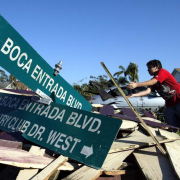
Rosemary Rayman2024-10-28 13:31:562024-10-28 13:48:30Hurricane Milton Operations Summary
Be Prepared: Why We Can’t Afford Complacency
The aftermath of a major storm in Florida can be unforgettable: blue-tarped roofs, piles of yard debris awaiting collection, and the absence of electricity, air conditioning, or clean water. Yet, these memories often fade as life returns to normal. However, for many Floridians, this period of calm can stretch on for years.
The last significant hurricane to impact our region was Wilma in October 2005. As time passes, people tend to forget the hardships of past events. Additionally, newcomers to the area may have never experienced a severe storm, leading to a sense of complacency and procrastination when it comes to emergency planning. However, the tranquility before the storm can swiftly change.
South Florida is renowned not only for hurricanes but also for sudden, intense thunderstorms that can bring torrential downpours any time of year. For instance, in January 2014, more than 15 inches of rain deluged a localized area within hours, causing severe flooding, property damage, and tragic loss of life.
It is crucial for residents to maintain year-round preparedness. This includes regularly checking and replenishing essential supplies like emergency food stocks, water storage, flashlights, and other necessities. Residents should also develop and maintain an evacuation plan, accounting for pets and family members with mobility challenges. Additionally, ensuring insurance policies are current and important documents are readily accessible is essential.
While we hope to navigate through the 2024 hurricane season unscathed, it’s inevitable that our luck may eventually run out. The importance of sustained preparation will then become strikingly evident. Valuable resources for emergency planning information can be accessed at www.ready.gov.

Storm Season – Are You Ready
Storm Season – Are You Ready
Time to gear up for the Atlantic Hurricane Season, spanning June 1 to November 30. Last year yielded 19 named storms and projections for this year indicate an even busier season. It is crucial to be ready. Regardless of whether our area experiences 1 or 30 storms, preparedness is paramount. The following list provides 3 steps you can take to ensure you are ready for whatever this storm season brings our way.
- Shop Early – Procrastination might work in some scenarios, but not when it comes to hurricane preparedness. Once a storm is looming, stores quickly run out of essentials, gas stations face endless lines and crucial hardware materials like plywood become scarce. Instead of waiting until the last minute, stock up on essentials during your regular shopping trips. Websites like ready.gov offer thorough checklists for your emergency kit, while www.floridadisaster.org shows you how to customize a plan based on your specific needs.
- Secure Your Neighborhood – Contributing to the safety of your neighborhood is essential during a storm. Clear drainage grates, ditches and swales of debris to prevent water blockages. Trim trees and remove dead vegetation but avoid doing so if a major storm is forecasted as there may not be time for sanitation pickup. Secure loose objects that could become projectiles in high winds like lawn ornaments, trampolines and trellises. Residents within the Lake Worth Drainage District (LWDD) boundary can find more information about the responsibility neighborhoods play have providing community flood control at lwdd.net.
- Have a Plan – If you plan to evacuate, having an evacuation plan in place is critical before a storm approaches. Identify if you are in an evacuation zone, establish and practice your evacuation routes. Know the location of your designated shelter and visit kidshealth.org for preparation tips for children and pets. Familiarize yourself with your surroundings and support systems to determine the best course of action for the safety of you and your family.
Following these 3 steps, you can better prepare yourself, your family and your community for the potential challenges of hurricane season. Stay informed, stay proactive, and stay safe.

Three Groups Working Together
Within Lake Worth Drainage District (LWDD), flood control is a shared responsibility and achieved through an interconnected, 3-tiered drainage system governed by 3 unique groups of people. Through communication and coordination, these 3 groups can provide effective flood control. The groups are identified as:
- Neighborhood drainage systems operated by property owners or residential associations
- Secondary drainage systems operated by LWDD or municipalities
- Primary drainage system operated by the South Florida Water Management District (SFWMD)
When it rains, water will flow into stormwater ponds and, if needed for flood control, out through the pond’s discharge control structure into the LWDD canal system. Excess water in LWDD canals will then flow into the primary SFWMD system for potential flood control discharge. Most of the time this drainage occurs unnoticed by the average individual.
Water managers in charge of primary and secondary systems are continually monitoring the weather and canal levels to proactively respond to changes in canal elevations. In anticipation of a heavy rainfall event, water managers will make operational adjustments to maintain appropriate water elevations for flood control. Additionally, throughout the year routine canal maintenance is conducted to provide unobstructed flow in the canal channel and access along the canal rights-of-way. The inspection of control structures, pumps and other infrastructure is also conducted, and repairs or replacements are made.
Property owners and residential associations have a similar role regarding their neighborhood drainage system. They must maintain their drainage infrastructure to ensure that inlets, storm drains, pipes, and discharge control structures are free of potential blockages and working as designed, thus maintaining the flow of stormwater away from their property. An annual inspection of the drainage infrastructure should be made, and repairs should be completed before the start of Hurricane Season on June 1.
Some neighborhood drainage systems have operable discharge controls structures and can request permission from LWDD to open their structure prior to a severe storm. This will provide additional onsite storage capacity within the stormwater pond. Guideline for the operation of neighborhood operable discharge control structures can be found at www.lwdd.net/storm-response.
Coordinating efforts and working together we can provide effective flood control.
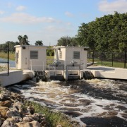
LWDD’s Automated Flood Control
Water control structures act like dams, allowing stormwater to be released or held back depending on weather conditions. The technology used to operate the Lake Worth Drainage District’s (LWDD) water control structures is called Supervisory Control and Data Acquisition (SCADA). As the water rises in the canal and reaches a pre-determined elevation, SCADA will slowly open control structures releasing water for flood control. Similarly, as water elevations return to normal levels the control structure gates will close, holding back water for conservation and water supply demands.
This response to changes in the canal system happens automatically and is monitored remotely by staff using mobile devices. However, in anticipation of severe weather, staff can override the automated SCADA system and make manual adjustments as needed. The remote monitoring and operating functions of SCADA eliminate the need for LWDD staff to venture out during dangerous weather conditions to operate control structures, as well as significantly reduce response time.
Automation for more enhanced flood control is just one of the many ways LWDD provides for your safety.
Office Location
