Inspector Gunther using tablet for data collection

Technology & Flood Control

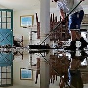
As the end of Hurricane Season approaches, we can all breathe a sigh of relief. No more listening for storm alerts and watches. No more storing of canned-goods, batteries, and water. No more worrying about flooding. Wait; not so fast, localized flooding in South Florida is always a possibility. It is just a fact; mother nature tries every day to return our area to the original swamp lands of yesteryear, and every day the Lake Worth Drainage District’s canal system works to keep that from happening.

Occurring any time of the year, our tropical rainstorms can be intense and seriously threaten property and life. In response, District staff monitors canal elevations daily and coordinates the operations of water control structures. Water control structures act like dams, allowing stormwater to be released or held back depending on the conditions. The automated technology used to operate the District’s water control structures is called Supervisory Control and Data Acquisition (SCADA). As the water rises in the canal and reaches a pre-determined elevation, SCADA will slowly open control structures releasing water for flood control. Similarly, as water elevations return to normal levels the control structure gates will close, holding water back for conservation and water supply demands. In anticipation of severe weather, District staff can override the automated SCADA system and make manual adjustments.

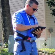
Additionally, SCADA technology eliminates the need for District staff to venture out during dangerous weather conditions to operate control structures. If needed, staff can adjust a control structure via a mobile device from any location, thus significantly reducing response time. Another advantage to SCADA, is the capture of operational data by the system which can be used to evaluate future water supply needs and historical flood control responses. This data can be shared with regional water management partners for enhanced flood control coordination and water conservation measures.

With approximately 500 miles of canals and 20 major water control structures, the Lake Worth Drainage District is one of the largest water control districts in Florida. We are proud to provide our residents with this enhanced water management technology and dependable flood control

Man cleaning flooded home

LWDD Helps Reduce Flood Insurance

The Federal Emergency Management Agency’s (FEMA) flood map informs your community about its local flood risk. It helps establish minimum floodplain standards so that your community builds safely and resiliently. It determines the cost of flood insurance, which helps property owners to financially protect themselves against flooding. The lower your degree of risk, the lower your flood insurance premium will be.

A community typically will be re-mapped because of population growth and development, better science, and changing conditions. FEMA and state and local governments develop partnerships and identify available data, which are used to aid in the discussion and design of the flood map.

The Lake Worth Drainage District plays an important role in the production of accurate maps for our service area. Current and historic flood-related data including hydrology, infrastructure, and hydraulics, were used to determine risk identification and assessment. Because of Lake Worth Drainage District’s canal network, water control structures, and regular maintenance program, many of our communities remained in FEMA’s lower risk areas. Final flood maps are posted to the online FEMA Map Service Center, making them easily accessible to the public at http://www.fema.gov/national-flood-insurance-program/map-service-center.

L-50 Canal east Boca Raton After Hurricane Irma

LWDD’s Canal Rehabilitation In The City of Boca Raton

At the request of Mayor Scott Singer on behalf of the City of Boca Raton, the Lake Worth Drainage District Board of Supervisors agreed at its July 11th Board Meeting to postpone vegetation removal along the L-48, L-49 and L-50 Canal rights-of-way within the City of Boca Raton. This postponement will allow the District and City the opportunity to work together and consider options for necessary canal rehabilitation on these canals prior to final action by the District’s Board of Supervisors on October 17, 2018.  The District will be moving forward with the following necessary canal work.

L-48 Canal:

  • Removal of stacked vegetation that was previously cut from right-of-way
  • Stump grinding vegetation previously cut along the south bank
  • Dredging silt from a portion of the channel adjacent to I-95
  • Excavation of shoaling east of Southwest 9th Avenue as may be necessary

L-49 Canal:

  • Placement of erosion control mats (jute fiber) along the top of canal banks west of 12th Avenue
  • Stump grinding of rubber tree previously removed west of Southwest 9th Avenue

L-50 Canal:

  • Inspection of outfall pipe located west of Southwest 8th Avenue, and remedial work of such as may be necessary
  • Removal of shoaling between 9th and 12th Avenues

Residents are reminded to take proactive measures for hurricane preparedness and sustainable tree maintenance by pruning trees away from drainage canals and refraining from planting trees or vegetation on drainage or utility easements and public rights-of-way.

Additional information and video on the District’s Canal Rehabilitation Program can be found on our website at https://lwddnet.wpengine.com/canal-maintenance/canal-rehabilitation. The City of Boca Raton’s website provides civic alerts at https://www.myboca.us/.

Rain flows down from a roof down

7 Fast Facts On Flood Control

Increase your knowledge about community flood control by downloading LWDD’s flyer, 7 Fast Facts On Flood Control, and get started on becoming informed partners in providing flood control.

7 Fast Facts