Frequently Asked Questions
There are a variety of options and techniques property owners can use to help reduce or eliminate nuisance-iguanas. Many of these strategies are simple and easily employed. This list of frequently asked questions will help guide you through this process.
Does LWDD provide eradication services for iguana infestations?
LWDD is a single purpose special district with the authority to provide flood control and water supply to the residents within its boundary. Tax assessments are collected for the maintenance and operation of these facilities. Iguanas typically do not interfere with LWDD’s flood control operations. However, where iguana activity is threatening significant damage to drainage infrastructure, LWDD may contract with professional wildlife managers to help control populations.
What might be attracting the iguanas to my property?
Typically, iguanas will use an area for foraging or for nesting. To prevent iguanas from entering your property consider what might attract them. Never feed iguanas – either intentionally or unintentionally. Food left outdoors will attract iguanas and can create problems for both you and your neighbors by creating dense concentrations of iguanas. Pans of cut fruit and outside pet food will attract iguanas as well as other unwanted visitors like rats and raccoons.
How can I prevent the iguanas from nesting?
You can remove protective covers including dense thickets, brush, or rock piles where iguanas congregate. Fill vacant iguana burrows with sand during the day when the animals are likely to be outside of the burrow. You do not want to fill these holes with any animals still inside.
Contrarily, some property owners have constructed artificial nesting habitats to attract iguanas. The purpose of this approach is to control reproduction. Iguanas lay their eggs in sand or mulch. By adding mulch piles or sand piles near sea walls, you can encourage iguanas to focus nesting on these controlled structures. Once eggs are deposited, they can be easily removed and then disposed of in a sealed plastic bag.
What type of landscape material can I plant to deter the iguanas?
Iguanas prefer to eat some very popular landscaping material such as: Hibiscus, Orchids, Roses, Nasturtiums, Impatiens and Purple Heart Plant. Iguanas prefer bright red, orange or yellow flowers and fruits and feed on tender leaves. Instead, plant species that are iguana-resistant, such as Milkweed, Pentas, and Citrus. Generally, plants with thick, tough, or waxy leaves will discourage iguana consumption. These types of leaves are less palatable and often difficult to digest. If the food source is removed, iguanas will be less likely to inhabit an area.
What types of exclusion techniques can I use?
Exclusion techniques can also be deployed to keep iguanas from damaging your property. Consider protecting valuable plants with cages or screen enclosures. Iguanas are excellent climbers. They may get into and on dwellings via overhanging trees. Trim overhanging branches to remove the unintentional “bridge” to buildings. Sheet metal guards on trees, palms, and dock pilings can prevent them from climbing.
Wire barriers can prevent digging on your property. In areas where iguanas burrow or dig, consider installing chicken wire fencing. This fencing should be buried several inches underground or the iguanas may dig underneath the fence.
What types of deterrent techniques can I use?
Several options can help you deter iguanas from your property. Property owners can surprise iguanas by spraying them with a water hose until they leave the area. You can also make loud noises to startle iguanas and create an unwelcome atmosphere around your property. Other techniques include hanging compact discs (CDs) near sea walls or on trees or other plants you want to protect. However, you will need to change the position of CDs on a weekly basis, so the iguanas do not become accustomed to their light reflections.
Is there an iguana repellent I can use?
While not proven, some property owners have experience success with iguana repellents. A homemade spray repellent can be made using garlic, lime juice, habanero pepper and dish soap. Iguanas loathe the smell of these ingredients and for the most part try to avoid the areas and any kind of food source that contains the smell of these ingredients. Using iguana repellents requires the need to redo the application each time it rains as the repellent will be washed away.
Where can I get professional help?
Residents are encouraged to seek professionals to remove iguanas from their property. Property owners can search the internet or phone book to locate wildlife control companies. Costs can vary depending on the extent of iguana infestation and the species of iguana that has invaded your property. Be sure to get a written quote from several service providers before contracting with a provider.
Can I kill the iguanas on my property?
Iguanas and all other wildlife are protected by anticruelty laws, and inhumane treatment of them is prohibited and punishable by state law. Inhumane treatment includes the use of poisons to kill iguanas; no poisons are legal to use on iguanas or any other reptile in Florida. Property owners that desire to kill the iguanas themselves must do so safely and humanely and follow the guideline provided by the Florida Fish and Wildlife Conservation Commission at https://myfwc.com.
Can a property owner or a professional service provider enter LWDD’s canal right-of-way to trap or provide iguana eradication services?
Prior to working on LWDD’s right-of-way authorization is required. Property owners and/or professional service providers should contact LWDD for authorization at 561-498-5363 or email to permits@lwdd.net.
Where can I find more information on iguana control?
Visit the Florida Fish and Wildlife Conservation Commission’s website at https://myfwc.com.
Ref: Frequently asked questions sheet was created from the Florida Fish and Wildlife Conservation Commission’s website.

Board Supervisors Carrie Parker Hill
/in News, ResidentialMs. Hill is a candidate for election for the Sub-District 4 seat at the Annual Landowners Meeting on January 4, 2023.
Ms. Hill is a seasoned professional with more than 40 years of experience in public sector management, specializing in coalition building, finance and budget management, and labor relations. During her distinguished career, she served as the City Manager for Boynton Beach, Village Manager for the Village of Golf, and Assistant Deputy Executive Director of Corporate Resources for the South Florida Water Management District. Ms. Hill is a University of Florida alumni where she earned her Bachelor of Science in Business Administration and Master of Arts in Political Science & Public Administration.
Ms. Hill is a resident of the Delray Dunes neighborhood where she currently serves as the HOA President. She is active in the community and has served as a Board member on the Palm Beach County School Board, Arthur R. Marshall Foundation for the Everglades, and Children Services Council of Palm Beach County.
Droughts Self-propagate, Just Like Wildfires
/in Drought, NewsExcerpt from Ghent University on the Phys.org website
Up to 30% of the rainfall deficit can be caused by “drought self-propagation,” the DRY–2–DRY European Research Council (ERC) project shows.
Unlike other weather extremes such as hurricanes or winter storms, droughts affect humans in most climatic zones around the world; from the arid steppes of the Sahel to the humid rainforests of Amazonia. Moreover, droughts are expected to intensify in many regions following global warming. The United Nations has recently described drought as “the next pandemic,” suggesting that the associated risks are currently overlooked. It is thus crucial to improve our understanding of drought, and particularly its causes, in order to be able to predict its future risk and enable adequate societal adaptation.
Rainfall deficits eventually manifest as dry soils. The land surface, though, also takes a very active role in the generation of rainfall, as it supplies moisture to the atmosphere through evaporation. What happens during a soil drought when far less water is evaporated than usual? It has been hypothesized that this can enable droughts to expand by themselves, as they provide less moisture for precipitation, not just locally, but also downwind. Until now, evidence of this drought self-propagation, fueled by the drying soils, had remained elusive. In a new study, published in Nature Geoscience, led by the Hydro-Climate Extremes Lab (H-CEL) at Ghent University (Belgium), this evidence is provided for the first time.
The authors analyzed the largest 40 droughts in recent history. For each event, the authors tracked the air over the drought regions as the drought area expanded. This allowed them to compute how much of the downwind rainfall deficits were caused by the upwind drying of the soils. Their conclusion was that in individual months, up to 30% of the rainfall deficit can be caused by this drought self-propagation. As Dominik Schumacher, first author of the study, states: “In essence, droughts behave similarly to wildfires: while fires propagate downwind by igniting more and more ‘fuel’ in their surroundings, droughts do so by reducing their own rainfall supply through the drying of the land surface.”
The authors find the strongest self-propagation in subtropical drylands, such as in Australia and Southern Africa—in these regions, the limiting effect of low soil moisture on evaporation is strongest. By definition, water is already scarce in drylands, yet these regions sustain a considerable fraction of the global human population and are also used extensively for farming.
Therefore, as drylands are projected to expand in light of climate change, the self-propagating character of droughts may lead to even larger and more rapidly evolving events in the future, and further exacerbate water scarcity as well as the attached socioeconomic and environmental consequences.
To find out more about current and historical droughts in Florida visit www.drought.gov/states/florida
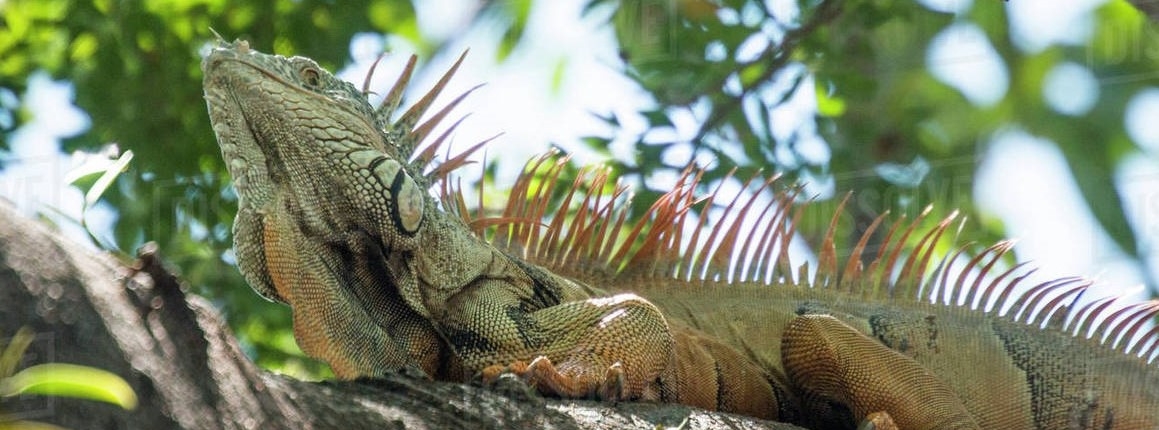
Iguana Control for Property Owners
/in News, ResidentialFrequently Asked Questions
There are a variety of options and techniques property owners can use to help reduce or eliminate nuisance-iguanas. Many of these strategies are simple and easily employed. This list of frequently asked questions will help guide you through this process.
Does LWDD provide eradication services for iguana infestations?
LWDD is a single purpose special district with the authority to provide flood control and water supply to the residents within its boundary. Tax assessments are collected for the maintenance and operation of these facilities. Iguanas typically do not interfere with LWDD’s flood control operations. However, where iguana activity is threatening significant damage to drainage infrastructure, LWDD may contract with professional wildlife managers to help control populations.
What might be attracting the iguanas to my property?
Typically, iguanas will use an area for foraging or for nesting. To prevent iguanas from entering your property consider what might attract them. Never feed iguanas – either intentionally or unintentionally. Food left outdoors will attract iguanas and can create problems for both you and your neighbors by creating dense concentrations of iguanas. Pans of cut fruit and outside pet food will attract iguanas as well as other unwanted visitors like rats and raccoons.
How can I prevent the iguanas from nesting?
You can remove protective covers including dense thickets, brush, or rock piles where iguanas congregate. Fill vacant iguana burrows with sand during the day when the animals are likely to be outside of the burrow. You do not want to fill these holes with any animals still inside.
Contrarily, some property owners have constructed artificial nesting habitats to attract iguanas. The purpose of this approach is to control reproduction. Iguanas lay their eggs in sand or mulch. By adding mulch piles or sand piles near sea walls, you can encourage iguanas to focus nesting on these controlled structures. Once eggs are deposited, they can be easily removed and then disposed of in a sealed plastic bag.
What type of landscape material can I plant to deter the iguanas?
Iguanas prefer to eat some very popular landscaping material such as: Hibiscus, Orchids, Roses, Nasturtiums, Impatiens and Purple Heart Plant. Iguanas prefer bright red, orange or yellow flowers and fruits and feed on tender leaves. Instead, plant species that are iguana-resistant, such as Milkweed, Pentas, and Citrus. Generally, plants with thick, tough, or waxy leaves will discourage iguana consumption. These types of leaves are less palatable and often difficult to digest. If the food source is removed, iguanas will be less likely to inhabit an area.
What types of exclusion techniques can I use?
Exclusion techniques can also be deployed to keep iguanas from damaging your property. Consider protecting valuable plants with cages or screen enclosures. Iguanas are excellent climbers. They may get into and on dwellings via overhanging trees. Trim overhanging branches to remove the unintentional “bridge” to buildings. Sheet metal guards on trees, palms, and dock pilings can prevent them from climbing.
Wire barriers can prevent digging on your property. In areas where iguanas burrow or dig, consider installing chicken wire fencing. This fencing should be buried several inches underground or the iguanas may dig underneath the fence.
What types of deterrent techniques can I use?
Several options can help you deter iguanas from your property. Property owners can surprise iguanas by spraying them with a water hose until they leave the area. You can also make loud noises to startle iguanas and create an unwelcome atmosphere around your property. Other techniques include hanging compact discs (CDs) near sea walls or on trees or other plants you want to protect. However, you will need to change the position of CDs on a weekly basis, so the iguanas do not become accustomed to their light reflections.
Is there an iguana repellent I can use?
While not proven, some property owners have experience success with iguana repellents. A homemade spray repellent can be made using garlic, lime juice, habanero pepper and dish soap. Iguanas loathe the smell of these ingredients and for the most part try to avoid the areas and any kind of food source that contains the smell of these ingredients. Using iguana repellents requires the need to redo the application each time it rains as the repellent will be washed away.
Where can I get professional help?
Residents are encouraged to seek professionals to remove iguanas from their property. Property owners can search the internet or phone book to locate wildlife control companies. Costs can vary depending on the extent of iguana infestation and the species of iguana that has invaded your property. Be sure to get a written quote from several service providers before contracting with a provider.
Can I kill the iguanas on my property?
Iguanas and all other wildlife are protected by anticruelty laws, and inhumane treatment of them is prohibited and punishable by state law. Inhumane treatment includes the use of poisons to kill iguanas; no poisons are legal to use on iguanas or any other reptile in Florida. Property owners that desire to kill the iguanas themselves must do so safely and humanely and follow the guideline provided by the Florida Fish and Wildlife Conservation Commission at https://myfwc.com.
Can a property owner or a professional service provider enter LWDD’s canal right-of-way to trap or provide iguana eradication services?
Prior to working on LWDD’s right-of-way authorization is required. Property owners and/or professional service providers should contact LWDD for authorization at 561-498-5363 or email to permits@lwdd.net.
Where can I find more information on iguana control?
Visit the Florida Fish and Wildlife Conservation Commission’s website at https://myfwc.com.
Ref: Frequently asked questions sheet was created from the Florida Fish and Wildlife Conservation Commission’s website.
Flood Control Resiliency
/in Flood Control, News, ResidentialHurricane Ian made landfall as a category 4 storm on September 28, 2022, on the west coast of Florida. This powerful storm brought with it winds of 140 mph and torrential rain. It reminds all of us at the Lake Worth Drainage District (LWDD) how important it is for public safety to have a well maintained and operating drainage system.
Effective drainage includes the free flow of water in the canal channel and unrestricted rights-of-way for regular maintenance activities as well as emergency response. Obstruction of drainage whether over the ground or within the canal channel can have devastating effects. During severe storms trees and large shrubs can topple over causing blockages in storm drains, swale areas or flood control structures. Blockages significantly increase the risk of flooding of homes, businesses and may lead to potential life-threatening events. Additionally, encroachments on the rights-of-way can severely hinder LWDD’s use of heavy equipment needed to keep residents safe during and after severe storms.
In response to the increased frequency and intensity of our hurricanes, tropical depressions, and thunderstorms, LWDD addressed flood resiliency and established the Canal Rehabilitation Program. Phase 1 of the program addresses removal of vegetative encroachments within the right-of-way and some structural encroachments that are limiting access to the canal. Phase 1 which was established in 2018 is expected to be completed in 2023.
Phase 2 of the Canal Rehabilitation program will continue to enhance LWDD’s flood control resiliency by addressing unauthorized structural encroachments, such as fences, sheds and patios, located within the canal rights-of-way which restricts maintenance access. These encroachments will be identified and prioritized for removal. Removal of the encroachments is required and is at the expense of the property owner. Dredging and reshaping of some canal channels may be performed during Phase 2 for increased function and operation of the system.
LWDD residents, both adjacent to canals and miles inland, will benefit from enhanced flood control as well as reduced cost in post-storm clean-up. Another benefit to vegetation and encroachment removal is the faster return of residential power following a storm event as an unencumbered right-of-way will facilitate utility restoration efforts.
Hurricane Ian may have passed by Palm Beach County, but it is only time until the next storm takes aim at our coast. LWDD is committed to providing the best possible flood control for our residents today and in the future.
Podcast -Tommy Strowd on Water Supply
/in Flood Control, News, ResidentialExecutive Director Tommy Strowd’s appearance on the Friends of Delray Podcast where he discusses the future of water supply in our area.
Watch Podcast