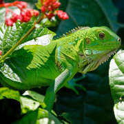
Control Structure general

LWDD’s Automated Flood Control

Water control structures act like dams, allowing stormwater to be released or held back depending on weather conditions. The technology used to operate the Lake Worth Drainage District’s (LWDD) water control structures is called Supervisory Control and Data Acquisition (SCADA). As the water rises in the canal and reaches a pre-determined elevation, SCADA will slowly open control structures releasing water for flood control. Similarly, as water elevations return to normal levels the control structure gates will close, holding back water for conservation and water supply demands.

This response to changes in the canal system happens automatically and is monitored remotely by staff using mobile devices. However, in anticipation of severe weather, staff can override the automated SCADA system and make manual adjustments as needed. The remote monitoring and operating functions of SCADA eliminate the need for LWDD staff to venture out during dangerous weather conditions to operate control structures, as well as significantly reduce response time.

Automation for more enhanced flood control is just one of the many ways LWDD provides for your safety.

Woman walking barefoot on wet floor

Prepare for Flooding: Helpful Links

Stay prepared for flooding throughout the hurricane season. No drainage system, no matter how well designed, is 100% flood proof. Whether you live in a flood-prone area or not, potential flooding from heavy rains may still affect you. Preparing for potential flooding requires action and the following list of links can help you get started.

First, know your risk for flooding. Visit FEMA’s Flood Map Service Center at https://msc.fema.gov/portal/home and locate your flood zone. Sign up for your community’s warning system with the Emergency Alert System (EAS) at https://www.fcc.gov/emergency-alert-system and National Oceanic and Atmospheric Administration (NOAA)  https://www.noaa.gov. Also, consider purchasing a weather radio to receive local emergency alerts and updates.

Additionally, residents can prepare for the potential impact of a flood by purchasing or renewing a flood insurance policy. Homeowner’s insurance policies do not cover flooding. It typically takes a new flood insurance policy up to 30 days for the policy to go into effect so the time to buy is well before a disaster. Visit https://www.floodsmart.gov for help with obtaining flood coverage under the National Flood Insurance Program (NFIP).

Most importantly, make a plan for your household so that you and your family know what to do, where to go and what you will need to protect yourselves from flooding. Learn and practice evacuation routes, shelter plans, and flash flood response. Gather supplies, including non-perishable foods, cleaning supplies and water for several days, in case you must leave immediately or if services are cut off in your area. Store important documents and photos in watertight plastic containers.

You can find more information and helpful tips at https://www.ready.gov/plan.

Hurricane Graphic

New Hurricane Tool

Cone of concern. Cone of dread. Cone of death. The National Hurricane Center’s (NHC) familiar forecast cone map goes by a lot of unofficial nicknames, all of which reflect this undeniable fact: you feel worried if you’re in it and better if you’re not.

That misreading of the forecast cone has made it the subject of some criticism over the years. Emergency managers believe it fails to reflect the risks posed to coastal communities that may be out of the cone one day but in it the next. Also, those in-land may be close enough to the eye of a storm to still experience serious wind damage.

This year, the NHC is rolling out an experimental version intended to address those issues by adding new layers of threats and a lot more colors. The NHC believes the new map better bridges the gap between informing the public and confusing it.

The forecast cone, introduced 22 years ago, has been misinterpreted by the public practically since day one. It’s meant to show the NHC best guess for where the eye of the storm will travel, with a cone around it that follows a formula based on the average errors the hurricane center makes when tracking a storm.

It’s a handy tool for showing where a storm may go. But even a small track shift can translate to a big change for a hurricane that parallels Florida’s long coastline. For example, the relatively minor shifts in the NHC predictions for Hurricane Ian’s path in 2022 led to entire counties in Florida exiting the forecast cone’s shaded area and, in some cases, delaying or avoiding calls for evacuation in response.

Starting August 15, the NHC will publish an experimental second version of the cone, where the inland spots under watches and warnings will also be colored in red and blue. It also will show the wind field of the storm, depicted in a gold tone, showing how far out the damaging winds stretch. This addition should make residents outside the cone more aware of the potential impacts from high winds. For more details on the new forecast cone visit NHC at https://www.nhc.noaa.gov/pdf/NHC_Cone_Graphic_Change_Announcement.pdf.

Excerpt from: Carter Weinhofer (May 15, 2024), New Hurricane Graphics Better Explain The Dangers of Approaching Storms,  Retrieved June 6, 2024 from https://www.yourobserver.com/news/2024/may/15/hurricane-graphics-dangers-storms

Roadway storm drain blocked by fallen leaves

Leaves Can Cause Flooding

See how a few leaves caused local street flooding in one South Florida neighborhood. Click the link to watch this incredible video https://youtu.be/R9PBy4_7zmM

man picking up trash from storm drain

Adopt A Storm Drain

Debris blocking storm drains can be a local flooding hazard. Even an average afternoon rainstorm can cause local street flooding if the water has nowhere to go. Just a small amount of debris and trash on top of a drain grate can reduce drainage capacity. By keeping the storm drain clear of debris, it can function as designed allowing storm water to flow away from your home and discharge into flood control canals.

Some helpful tools for cleaning a storm drain include: a broom, a rake, a trash grabber, gloves, an orange cone and/or safety vest, a shovel or dustpan and a pail or yard waste bag. Never remove the grate or otherwise attempt to clean inside the catch basin. Clean only the surface of the storm drains grate and the area around it. If the drain appears to be plugged or have any problems, contact your community board/property manager or local municipality to address the issue.

Adopting a storm drain only takes a small amount of time. Let friends and neighbors know about your commitment and invite them to adopt a storm drain too.