Drainage Check-up For The New Year
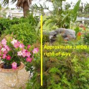
Throughout the year, the Lake Worth Drainage District (LWDD) oversees the operation and maintenance of approximately 500 miles of canals and 1,000 miles of canal rights-of-way. In addition, LWDD operates 20 major water control structures which release or hold back water depending on conditions. However, effective flood control takes more than just LWDD. Property owners and residential communities all have a role to play in the overall flood control system.
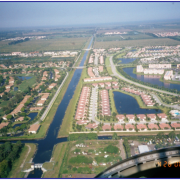
In South Florida, flood control is a shared responsibility and is achieved through an interconnected, three-tiered drainage system. This three-tiered system is made up of tertiary or neighborhood drainage systems operated by property owners or residential associations; secondary drainage systems which are operated by LWDD, county or municipalities, and the primary system operated by the South Florida Water Management District (SFWMD).
The role of property owners and residential associations is like that of LWDD in that they retain stormwater onsite in retention ponds/lakes for water quality purposes and discharge excess stormwater for flood control. They must maintain their drainage infrastructure to ensure that catch basins, underground pipes and discharge control structures are working as designed.
South Florida’s dry season runs from approximately October to May. January is the ideal time of year to conduct inspections of drainage infrastructure and make any necessary repairs. Additionally, the start of a new year is when many residential boards hold elections and change property management companies. It is important to register these changes with LWDD to ensure the correct individuals are receiving important weather alerts and flood control instructions. Taking time during the dry season will help ensure that your property is ready for the coming rainy season. For more information on flood control or to submit contact information, visit LWDD’s website at www.lwdd.net/property-managers-hoa.