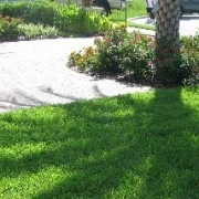
L-50 Canal east Boca Raton After Hurricane Irma

LWDD’s Canal Rehabilitation In The City of Boca Raton

At the request of Mayor Scott Singer on behalf of the City of Boca Raton, the Lake Worth Drainage District Board of Supervisors agreed at its July 11th Board Meeting to postpone vegetation removal along the L-48, L-49 and L-50 Canal rights-of-way within the City of Boca Raton. This postponement will allow the District and City the opportunity to work together and consider options for necessary canal rehabilitation on these canals prior to final action by the District’s Board of Supervisors on October 17, 2018.  The District will be moving forward with the following necessary canal work.

L-48 Canal:

  • Removal of stacked vegetation that was previously cut from right-of-way
  • Stump grinding vegetation previously cut along the south bank
  • Dredging silt from a portion of the channel adjacent to I-95
  • Excavation of shoaling east of Southwest 9th Avenue as may be necessary

L-49 Canal:

  • Placement of erosion control mats (jute fiber) along the top of canal banks west of 12th Avenue
  • Stump grinding of rubber tree previously removed west of Southwest 9th Avenue

L-50 Canal:

  • Inspection of outfall pipe located west of Southwest 8th Avenue, and remedial work of such as may be necessary
  • Removal of shoaling between 9th and 12th Avenues

Residents are reminded to take proactive measures for hurricane preparedness and sustainable tree maintenance by pruning trees away from drainage canals and refraining from planting trees or vegetation on drainage or utility easements and public rights-of-way.

Additional information and video on the District’s Canal Rehabilitation Program can be found on our website at https://lwddnet.wpengine.com/canal-maintenance/canal-rehabilitation. The City of Boca Raton’s website provides civic alerts at https://www.myboca.us/.

Rain flows down from a roof down

7 Fast Facts On Flood Control

Increase your knowledge about community flood control by downloading LWDD’s flyer, 7 Fast Facts On Flood Control, and get started on becoming informed partners in providing flood control.

7 Fast Facts

trees with wind

Before, During & After The Storm

Florida’s hurricane season begins on June 1 and ends November 30. Based on historical weather records dating back to the 1950s, a typical season will average 12 tropical storms with sustained winds of at least 39 miles per hour, of which six may turn into hurricanes with winds of 74 miles per hour or more. In addition to high winds, hurricanes and tropical storms can bring torrential rainfall. These severe weather events can produce localized flooding that can be exacerbated by improperly maintained drainage systems.

Residential communities and businesses can help mitigate the impacts from severe storms with a few simple steps. One of the most important steps is the regular inspection and maintenance of drainage infrastructure. Drainage infrastructure can include inlets, discharge control structures, connecting pipes and lakes. Proper maintenance of these facilities will ensure unobstructed flow of stormwater and fully operational equipment. Secondly, residential communities and businesses with operable discharge control structures can request authorization from the Lake Worth Drainage District to open these structures prior to the storm. Lowering lake levels provides additional storage for excess stormwater. The Lake Worth Drainage District recommends establishment of a Drainage Committee whose role is to provide for the maintenance and operation of the community or business’ drainage system. Drainage Committees may consist of board members, residents and/or property managers. All members of the Drainage Committee should register with the Lake Worth Drainage District on its website at www.lwdd.net. This registration process ensures the Lake Worth Drainage District knows who to contact and where to send important weather alerts and instructions.

During the storm event, follow emergency management instructions via the television or radio and take appropriate actions to keep yourself, family and property safe. In most circumstances, emergency personnel will not be deployed during the weather event. Depending on the volume and duration of rainfall, expect streets, sidewalks, driveways and lawns to flood. These areas are designed to act as secondary detention areas and help to keep water away from homes and businesses. This flooding is temporary and will begin to recede after an event has passed. Using its SCADA Automated System, District personnel will be monitoring canal elevations and making operational adjustments to major flood control structures as needed. This work can be conducted during the storm via wireless mobile devices and provide instantaneous response to changes in water elevations.

It may be tempting to explore outside but stay indoors after the storm. For your safety and to keep roadways clear for emergency response vehicles stay inside until told otherwise by authorities. Do not attempt to walk in flooded areas. Flood water may be unsanitary and there may be downed power lines or other hazards that are not visible. Also, do not attempt to drive through flooded areas. Vehicles can become unstable and float in as little as a few inches of water. Additionally, canal banks may fail and roadways may be affected by sinkholes. The location of roads and sidewalks may not be discernible from canals and lakes and life-threatening accidents can occur.

While weather predictions are becoming more sophisticated, forecasters are still unable to predict exactly where a storm will make landfall. The likelihood of flooding depends on several variables such as rainfall volume, ground moisture and local terrain. No system, no matter how well designed, is 100% flood proof. The Lake Worth Drainage District works closely with residential associations, businesses and other water management agencies to help keep you and your property safe from potential flooding.

GIS Snap Shot

Got Maps?

GIS data and various maps are available to the public on our online GIS Mapping Portal located on the top menu bar under the tab Resources. On the portal you will find maps and information on LWDD’s boundaries, canals, water control structures, permits and maintenance activities. If you cannot find what you are looking for, contact us at 561-498-5363 or email info@lwdd.net.